| |
| |
|
|
| |
| Introduction |
|
The tools surveyed in this article assist in successfully pedestrianizing a part of the city, but this will only work if certain basic conditions are met. These conditions are that the city itself is dense enough to sustain pedestrian activity. Low density cities have their destinations too spread out and their streets are too empty to provide for pleasant pedestrian spaces. The most successful spaces without cars are those either in highly dense city environments or those created around shopping areas, conference centers and seaside boulevards, in short, places where people congregate in high numbers. Whereas with cars one wants to reduce congestion, in a way with pedestrianization one wants to encourage it, to a certain extent. People are attracted to areas with a lot of other people, and the fluidity of movement when walking makes for effective flow only inhbited in the most extreme of circumstances. Many destinations in the same area, mixed with offices and residential buildings have to provide for twenty four hour occupancy, and never leave the streets bland and desolated. Of course all the advantages of Jane Jacobs' explorations in these areas are valid. A higher degree of interaction between people implies certain unspoken trust, the cohabitation between different demographics helps to break down barriers of misunderstanding between cultures and age groups, and so on. But that discussion is beyond the scope of this article. What is clear is that a city is a complex entity, that is not easily manipulated by means of just material interventions. One should look at different scales, cultural consequences and inhibitors, issues of safety, capacity, aesthetics and as with most things of importance in our lives, it is important to pay attention to detail. Once can have the best transportation system in the world but when you don't have sidewalks which have small ramps to the streets and at pedestrian crossings, anyone with a suitcase, handicapped and hand cargo delivery becomes a problem that will inhibit the more expansive use of such a system. All these little things add up and provide the whole experience that is a city and its usability.
|
|
Applying Pedestrianization Tools |
List of tools in this survey: |
Many of the tools in this survey provide basic services to the pedestrian. Most of them have some sort of material purpose, such as making sure groups of children are not run over, and so on. All of them, however, of which some specific, have a purely psychological function. Of these one of the most important is the realization that the pedestrian movement is inherently different than of any other mode of transport, even bicycles. Walking is moving in an amorphous space. At any point can one turn and walk back, turn any direction, stop or go faster. That is the freedom and rich experience of walking. Organizing pedestrians as if they are cars, with many linear pathways, is counter intuitive and is the highway planner’s approach to pedestrianization. This simply does not work. A large open square with nothing but some benches works far better as a pedestrian space than a highly organized square with big lanes, small lanes, thoroughfares and so on. Pedestrians also change their mind all the time. So for access you would like to offer different routes to reach the same places. Multiple subway entries in the same area is a good example of this, but also section change assists should be executed in multiple. In addition, the pedestrian experience is highly enriched by variety, nature and aesthetic conditions. Public art, variation of pavement, small parks, benches, shaded and covered areas versus expansive open space, small stores and big ones intermixed, clear meeting points, streets with character and allure all help to make a mediocre space that few people would like to walk through into a wonderful space for many. These kinds of interventions are often not visible on urban plans but help to shape the success of these plans as much as the larger ideas.
|
- Connected pedestrian & bicycle network
- Clear pedestrian preference & sidewalk expansions / Soft Edge
- Sectional change & distance assists
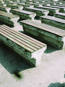
- Urban furniture
- Amorphous VS linear pedestrian areas
- Daily necessities close by
- Three-scale park network
- Second Generation Traffic Calming / Shared Space
|
1 - Connected pedestrian & bicycle network
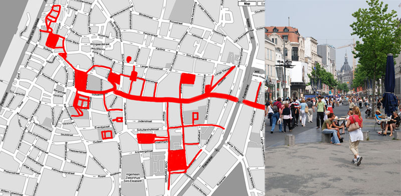
Pedestrian areas augment each other. Several dispersed pedestrian areas don’t work as well as connected ones, since the walk range of an individual is limited, but usually larger than a single pedestrianized street. The larger the area within a half hour walk radius, the more attractive it becomes. Cities like Amsterdam, Antwerp, Copenhagen and Delft have developed various systems for this. On the left the networks of Antwerp and Copenhagen. The Antwerp network (fig 1) is interesting since it consists of a central spine but has subsidiary routes snaking around it, with most pedestrian squares no on this spine. Since this street (Meir, fig 1) is already wide enough to be seen as an expansive space, it helps to have these squares dispersed in the more dense small scale fabric of the city. Although all areas that are not red are not pedestrianized absolutely, they are still areas that favor pedestrians over cars. Cars drive slowly, have difficult corners to navigate and the amount of people on the street make it hard to drive through, which discourages auto use. Cars are often parked in one of the many garages in the ring around the old city from where one travels further on foot.
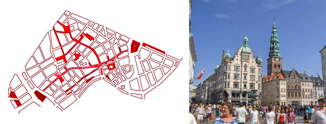
Copenhagen (fig 2) follows a similar pattern, but without the solid central axis. Also, Copenhagen has a larger network of streets that discourage but not entirely disallow car traffic. This also mainly due to the fabric of the medieval city that necessitates allowing access in certain areas throughout the day. The city center is still very much a pedestrian area that many people find very pleasant to live and work in.
|

fig 1. Antwerp Pedestrian Network and Meir, the main street of the area.
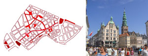
fig 2. Copenhagen Pedestrian Network and Hojbro Plads, a square in the area.
|
2- Pedestrian preference & sidewalk expansions
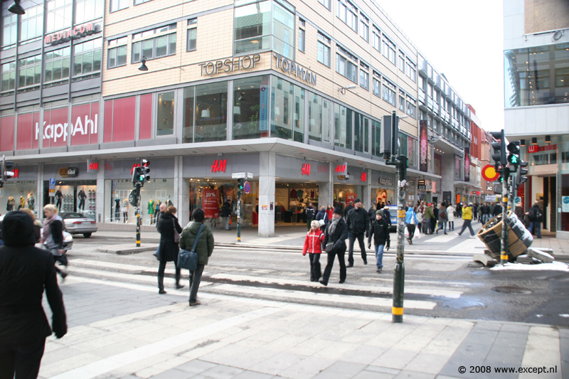
Figure 3 shows a situation in Stockholm in an area of pedestrianization where a car street meets a pedestrian street. This would be called a pedestrian crossing, but it could more accurately be described as a car crossing. The width of the crossing favors the pedestrians, and here one can cross without harm even when the light is red due to the imposing width of the crossing for the pedestrians. There is no ambiguity here who has the right of way, and there is very little chance of cars rushing by. This improves safety for the pedestrians, as well as make a clear hierarchy in which the person in the car does not feel superior. That all assists in promoting a different mode of transport.
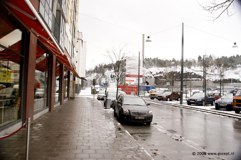
In figure 4 one can see a standard side walk in one of the newer suburbs of Copenhagen called Hammarby Sjostad. This great piece of urban design assures the maximum walk to a light rail connection to be five minutes, and promotes pedestrian usage of the streets. Shown in the photograph is the standard side walk width, not a particularly wide one. This width allows four people to walk next to one another comfortably and for certain informal meetings and events to take place in the public domain. One can stand around without being a nuisance to anyone and mothers with children on tiny bicycles have enough space to participate as well as anyone else. |
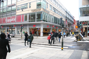
fig 3. Stockholm pedestrian crossing
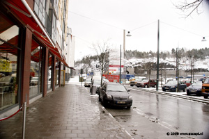
fig 4. Stockholm sidewalk
|
3 - Soft Edges
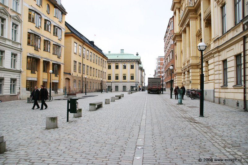
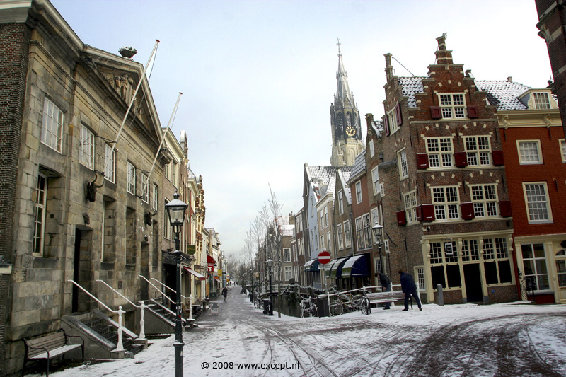
In figure 5 one can see a street where the distinction between pedestrian area and the two lanes of traffic are ambiguous on purpose. This 'soft edge' approach leads to the more careful entering and participation of motorized traffic in these areas, where pedestrians could be roaming about anywhere. It’s a psychological device that blends the rules of the spaces, giving up the street, which is normally the exclusive domain of the car, to the pedestrian in part. The road surface helps in this, as it’s a typical pedestrian surface rather than asphalt or concrete. Also figure 6 shows a soft edge area in Delft in the snow. The entire inner city area of Delft is soft edges in combination with a limited entry policy for cars. Driving in this part of the city makes one very aware of the role of the car versus the pedestrian. You’ll only do it when you really have to, and you’ll take your time doing it. It feels like driving your car through a carnival on a busy day when everyone comes out and walks around. Having personally experienced the transition from full car use to limited to no cars allowed in the entire inner city district of Delft I have to say that it was unpleasant for a while to transition out of your daily habits, but the quality of the city has increased by enormous amounts in the sheer freedom to walk or ride a bicycle through these areas, and in the end the result is highly successful. Bicycles are of course allowed (this is the Netherlands, afterall), but do not have designated areas of use. Instead the negotiations become a largely amorphous ensemble that regulates itself. On busy days the bicycles go slower and watch carefully for pedestrians. On quiet days the pedestrians look out for fast bicycles before making sudden leaps across the road. A more integrated solution of soft edges can be found in the Shared Space tool further down. |

fig 5. Stockholm soft edge
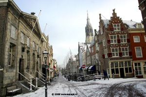
fig 6. Delft soft edge
|
| |
|
| all contents of this website are © 2008 except |
 |
|
|
|